
WE NEED YOU TO MAKE SUBMISSIONS ON 2 DEVELOPMENT APPLICATIONS. THE FIRST IS DUE ON 7 FEB AND THE SECOND ON 21 FEBRUARY.
WE URGE YOU TO MAKE A START ON WRITING YOUR SUBMISSIONS

BRG’s Dailan Pugh has started work assessing both DAs and there are some serious concerns about this proposed new mega-suburb.
Dailan’s DRAFT is set out below and can be downloaded as a PDF by clicking here.
DRAFT SUMMARY Note the draft below only deals with Development and the directly impacted Environment. It is yet to assess the key issue of Stormwater impacts on adjoining wetlands and the Belongil Estuary. While incomplete it is being circulated now because of the limited timeframe. Dailan Pugh 6 January.
Two Development Applications are currently on display for the bulk of the West Byron Urban Release Area.
- The Local Landholders Development Application (DA) for the bulk of the site (the Belongil Fields area) is on exhibition until 7 February, and the
- The Villaworld DA has been re-exhibited until 21 February (these are hidden on Council’s website under the guise of ‘various properties’).
Submissions are to Byron Council submissions@byron.nsw.gov.au and must refer to: Development Applications: 10.2017.661.1 – Various Properties (herein termed Local Landholders) and 10.2017.201.1 – Various Properties (herein termed Villaworld).
DEVELOPMENT ISSUES
The two exhibited DAs propose to create:
– 659 residential lots from as small as 205m2 up to 3,386m2
– two lots for a village centre totalling 8,072 m2, and
– two industrial lots totalling 13,922 m2.
Most of the industrial zone will be subject to a future DA. From this review it is considered that these will ultimately allow for subdivision into over 1,000 residences. Within the Low Density Residential (R2) areas, both DAs are proposing medium density developments and superlots which are intended for future medium to high density development.
The layout plans for both DAs are proposing subdivision into lots smaller than allowed for by LEP 1988 Division 2 (81) in the R2 zone, with the Villaworld DA proposing 4 duplex lots less than 600m2 and the Local Landholder’s DA proposing 14 lots less than 450m2. Based on this review it seems that many more lots shown are less than the 450m2 allowed.
While the DCP allows for residential flat buildings in the R2 zone, this is considered contrary to the objectives of the zone and in contravention of the LEP West Byron clause 82.
The design of both subdivisions are clearly in contravention of the DCP E8.10.3 requirements relating to street layout by not allowing space for incorporation of swales into road verges, and in the medium density zone (or proposed medium density lots) by not allowing space for nose in parking, and in places no rear access or street parking at all.
There is a need for a redesign of the proposed layouts for both DAs that comply with the minimum lot sizes, to allow for swales to be incorporated into road verges, include allowance for adequate parking, and clearly identify all lots proposed. It is considered that for Local Landowners this has to involve removing inappropriate development from the Ezones and minimising impacts.
There has clearly been no single DA submitted for the Industrial Zone as required by the DCP E8.10.10.4, rather 2-3 lots (depending on which map) are proposed with only an indicative outline of what could go on the sites. This clearly does not satisfy requirements and should be refused. Particularly as one of the lots intrudes into a Coastal Wetland.
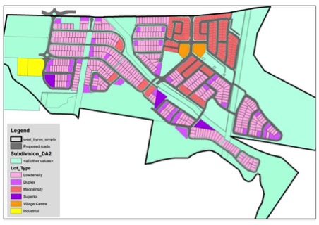
Map showing proposed distribution of lots across both DAs. The DAs are deliberately vague and ambiguous about what is intended on the larger lots, and their development potential.
Inconsistencies between DAs
The two DAs are not compatible regarding road locations and drainage infrastructure, with a number of roads misaligned by as much as 25m, inconsistent roundabouts, and a swale and drainage line proposed by Villaworld being filled in downstream by Local Landholders for a road. Both DAs use different parameters for traffic generation.
Both DAs have inconsistent strategies to mitigate impacts on Koalas and Wallum Sedge Frogs, with Local Landholders proposing to allow dogs and fence out Koalas and Villaworld proposing to exclude dogs — diametrically opposed at the intersection of the two developments.
This emphasises the need for both DAs to be withdrawn and to be made compatible.
Traffic
This development was approved on the false claim that it would only generate 6,000 vehicle trips per day on Ewingsdale Road. The same consultant is now saying it will generate over 14,000 vehicle trips per day. This assessment is that it will generate over 16,000 vehicle trips a day onto Ewingsdale Road which will obviously have major and dramatic affects on the efficiency and ongoing operation of Byron’s main road in contravention of clause 101 of State Environmental Planning Policy (Infrastructure) 2007.
The proposed development of West Byron is just too big for the Ewingsdale Road or the roundabouts near the town centre or available parking in town to be able to cope. Ewingsdale Road is already beyond capacity at peak times and there is a significant Loss of Service. West Byron will significantly increase the stress on Ewingsdale Road and the town’s infrastructure, and have an adverse effect on the local community and the tourism industry. In the absence of a solution the development needs to be scaled back to a level where the “safety, efficiency and ongoing operation of the classified road will not be adversely affected by the development“.
Cut and Fill
The proposal is to fill most of the site to 0.5m above the assessed flood level, which requires fill up to 3m deep. It is intended to import some 500,000 m3 of fill, which can be expected to weigh around a million tonnes. Though both DAs fail to identify the quality and source of the fill in contravention of LEP 1988, 98B Earthworks 3(f), There has been no attempt to assess the impacts that the thousands of truck movements will have on both traffic and the pavement on Ewingsdale Road. The fill maps of the 2 DAs are not consistent, with differences of over a metre, and another assessment claims the total fill as only 300,000m3.

Combined fill for West Byron, note the gross inconsistencies between DAs to the west.
Acoustic Barrier
Ewingsdale Road is the principal entry to town and thus provides visitors with their first impression of Byron Bay. The current rural landscape is an important contributor to the perception that Byron Bay is a small coastal town, which is an important aspect of its tourism appeal. A vegetated buffer to Ewingsdale Road is required to obscure the proposed housing estates to help maintain Byron’s tourism appeal.
The proposals involve filling of the development up to the boundary of the Ewingsdale Road to a depth of 0.5 to 2.1 metres deep. Local Landholders are proposing a 2m earth mound topped by a 2m acoustic barrier on top of the fill. Villaworld’s acoustic report prefers scenario 1 of a 1.8-2.6m high acoustic wall on top of the fill, though also considers a Scenario 2, which has walls 2.4-4m high (if Local Landholders are a guide it may be Scenario 2 that is adopted). It seems that the finished walls may be up to 6m above ground level, with the walls situated right on the boundary of the road reserve.
The proposals involve providing the visual buffers with the road reserve, comprised of a planted earth mound 6m wide, though they will likely need to be wider where the fill is deep. This is considered an inadequate screening for such an important tourist route and the gateway to Byron Bay.
The Ewingsdale Road Reserve is 28-40m wide, and is proposed for 4 lanes which could require up to 30m. The full width of the road reserve should be retained for current and future transport needs. The intrusion into the road reserve is strongly objected to,
There is a need to reconsider the acoustic and visual buffering of the development. Any mounds and concrete barriers needed for noise management need to be set well back from Ewingsdale Road on Villa World’s and Local Landholder’s properties and provide an effective visual buffer.
DIRECT ENVIRONMENTAL IMPACTS
The higher areas of West Byron were historically a dunefield extending up the coast to the Tyagrah Nature Reserve. The dunes have been levelled and the “drains” are straightened wetlands and streams from the interdunal swales. The east and south were part of the Belongil Intermittently Closed and Open Lake and Lagoon wetlands that have been drained by the manual opening of the sand berm at the mouth over the past few decades. The Belongil wetlands would have extended far up the interdual swales.
There are 35ha of remnant native vegetation (as mapped by Byron Shire Council) on the West Byron Urban Release Area of which 10.6 ha of native vegetation is proposed for clearing, variously comprised of:
- 8 ha of existing environmental zones E2 and E3
- 8ha of BSC proposed additions to Environmental Zones.
- 1 ha of mapped SEPP Coastal Wetlands, as well as extensive areas of vegetation within 100m SEPP Coastal Wetlands Proximity Areas, and the Coastal Environment Area.
- 0 ha of identified core habitat of the nationally vulnerable Koala.
- 57 ha identified as breeding habitat of a significant population of the nationally vulnerable Wallum Sedge Frog.
- 65 ha identified as the Endangered Ecological Community Paperbark swamp forest of the coastal lowlands of the NSW North Coast Bioregion and Sydney Basin Bioregion.
- 6 ha of over-cleared Mitchell Landscapes: Byron – Tweed Alluvial Plains (81% cleared) or Byron – Tweed Coastal Barriers (72%).
To some extent the DAs rely upon outdated vegetation and values mapping undertaken by Byron Shire Council, and have ignored the significantly improved recent vegetation mapping. The Local Landholders also understate the area of vegetation proposed for clearing.
Byron Shire Council identify 3 Endangered Ecological Communities on West Byron: Coastal Cypress Pine (0.27ha), Lowland Rainforest (0.06ha), and Swamp Sclerophyll Forest on Coastal Floodplains (0.79ha). There will be small areas of all these cleared. Though a Villaworld consultant identifies an additional stand of 0.65 ha of the EEC Swamp Sclerophyll Forest on Coastal Floodplains that is intended to be cleared, though this is not acknowledged or considered in their assessment of impacts.
Environmental Zones
Numerous intrusions involving the clearing of 1.8 ha are proposed into the E2 (Environmental Conservation) and E3 (Environmental Management) zones. Associated works will cause more damage. There has been no attempts to identify, assess or mitigate the impacts these works will have on a variety of ecological attributes, including core Koala habitat and feed trees, coastal SEPP wetlands, streams, Wallum Froglets and Wallum Sedge Frog.
Intrusion into the Environmental zones for the bicycle track, footpaths, fill batters and an unexplained clearing would appear to be prohibited and contrary to the allowable uses specified in the LEP (78 and 79). The DCP’s (E8.10.5.1) requirements to protect the values of the Ezones has not been honoured and the 20m buffers (DCP E8.10.5.1) not implemented in a number of areas (ie where roads do not provide a default “buffer”) and management plans not prepared. It is considered that the impacts of stormwater intrusions into E2 and E3 zones have not been appropriately identified and justified in accordance with the LEP (98A(3)(a)). It is apparent that many of the intrusions could have been avoided and sited within the urban zones, and that others could be redesigned or include special provisions to reduce impacts.
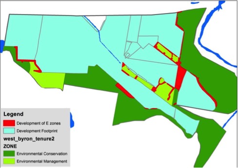
Map depicting proposed incursions into Environmental Zones. Note that while Villaworld have redesigned and re-exhibited their proposal so as to remove incursions into Ezones, the Local Landowners have treated them as part of the developable area, with many unnecessary and unjustified incursions,
High Ecological Value Vegetation
The proponents have not considered Council’s current vegetation mapping, the NSW Government’s High Environmental Value criteria, Council’s identification of HEV vegetation or Council’s exhibited Ezones. In contravention of section 79C of the EPA Act Council’s draft Environmental Zones were not considered despite being on exhibition prior to the exhibition of these DAs. Villaworld cited out of date and now irrelevant information, while the Local Landowners just ignored the whole issue.
Coastal Management State Environment Planning Policy (SEPP)
Neither DA has given due consideration to the draft State Environment Planning Policy (Coastal Management) 2016, neither of them have made any attempt to consider their impacts on currently mapped Coastal Wetlands (and the requirement for an EIS) or the Coastal Environment Area. The Local Landholders only identify that they objected to the Coastal Wetlands Proximity Area, while failing to assess their impacts upon it (they need to recognise that their industrial sites and numerous incursions into Ezones require compliance). Villaworld claim compliance with the proximity area requirements through other assessments. The DAs are therefore not compliant with Section 79C of the EPA Act in that they have not fully considered “any proposed instrument that is or has been the subject of public consultation“.

NSW Government’s current mapping for State Environment Planning Policy (Coastal Management) 2016, overlaid on the proposed development. Note the purple areas are identified wetlands proposed for filling. This mapping and the SEPP requirements are largely ignored by the proponents.
FAUNA
Thirteen Threatened fauna species under the NSW TSC Act 1995 have been recorded on West Byron, with 4 of these listed under the Commonwealth EPBC Act 1999..
There has not been an attempt to consider impacts on threatened species and ecological communities in accordance with the Biodiversity Conservation Act 2016 instead of the repealed Section 5A of the Environmental Planning and Assessment Act 1979. Development is considered likely to have a significant effect on Wallum Sedge Frog and Koalas, meaning a Species Impact Statement or a Biodiversity Development Assessment Report must be prepared for these species. The development should be referred to the federal Minister in accordance with the EPBC Act.
Koala
The evidence suggests that the Koalas on West Byron are part of a fragmented coastal Koala population comprised of just 240 individuals, relying on small isolated patches of core habitat and scattered feed trees, while depending upon dispersal amongst the population for their ongoing viability and persistence. The West Byron site is a key node and a vital link for maintaining connectivity between Koalas to the north and south. The concern is that if this link is severed that the isolation of the northern and southern Koalas will render their populations unviable.
It is considered that the AWC Koala Plan of Management is inadequate in that it:
- Does not meet the objective of SEPP 44 to “encourage the proper conservation and management of areas of natural vegetation that provide habitat for koalas to ensure a permanent free-living population over their present range and reverse the current trend of koala population decline”:
- Does not cover the whole site and is contradictory to proposals for the balance of the site.
- Does not recognise the presence of core Koala Habitat.
- Endorses the removal of 37% of core Koala habitat on the site.
- Endorses significant removal of core Koala habitat and feed trees in Ezones.
- Fails to identify the location and size of Koala feed trees throughout the site to enable a proper assessment of impacts and mitigation measures.
- Is inconsistent with the draft Byron Coast Comprehensive Koala Plan of Management (2015).
- Is inconsistent with Byron Shire Development Control Plan 2014 – Chapter E8 – West Byron Urban Release Area.
- Ignores requirements for 50m buffers around core Koala habitat.
- Fails to account for the time lag of decades between planting trees and their providing significant browse, and the increased use of trees with age.
- Proposes fencing of unspecified areas to exclude Koalas/dogs (with no ability to consider feasibility or impacts) instead of excluding dogs from the development,
- Misrepresents and selectively uses background information to mislead the reader.
It is recommended that the NSW Minister for the Environment immediately adopt the draft Byron Coast Comprehensive Koala Plan of Management (2015) without further delay so that Koalas are given due consideration at West Byron.
The developers should be required to remake their plans so that they are consistent with the Byron Coast Comprehensive Koala Plan of Management, Byron Shire Development Control Plan 2014 – Chapter E8 – West Byron Urban Release Area and fully satisfy the objective of SEPP 44.
Koala Core Habitat
The evidence is that there is a resident population of koalas centred on Belongil Fields. There have been 5 systematic Koala scat searches since 2010 and they all indicate a widespread and permanent Koala presence on the site. In April 2010 Biolink undertook surveys that identified widespread Koala activity on the site, 2 Koalas and core Koala habitat. In November 2010 AWC undertook surveys that identified widespread Koala activity and 2-3 Koalas. At sometime in 2015 AWC undertook a scat survey that identified widespread Koala activity In April 2015 Cristescu and Schultz undertook a scat-based survey that identified widespread Koala activity, including 3 sites with scats <24 hours old. In 2016 Koala scats were recorded at one site (part of the Belongil Fields core area) by Planit.
The identified Koala habitat on the site is thus core Koala habitat within the meaning of State Environmental Planning Policy No. 44 (Koala Habitat Protection) and should be protected. There is no evidence to support Local Landholder’s claims that Koalas are transient. Similarly the AWC’s and Planit reports selectively cite information and make misleading claims that the site is incapable of supporting even one Koala. To the contrary the evidence is that the 5.5ha of Koala habitat on the site and feed trees scattered throughout other vegetation and cleared areas, are easily capable of supporting a number of Koalas. Though given the limited habitat the loss of any feed trees, increased barriers to dispersal between feed trees or increased mortality could have significant impacts on the ability of the site to support resident Koalas into the future.

Map depicting existing Environmental Zones, Koala habitat, Koala habitat buffer (50m), Koala records since 2010, and apparent principal area of Koala use.
Clearing of Core Koala Habitat
According to Council’s mapping there is 5.5ha of Koala habitat on the site, as well as feed trees scattered throughout other vegetation and cleared areas of the site. The footprint of the development identified in DAs will result in the clearing of 2.04ha (37%) of Koala habitat, comprised of 1.56ha zoned for development and 0.48ha within environmental zones, as well as an unspecified number of scattered feed trees.
Planit consultants rely upon outdated Koala habitat mapping by Byron Shire Council to wrongly claim that no mapped habitat is proposed for removal by Villaworld. AWC utilises understated habitat mapping to claim that Local Landholders only intend to remove 1.47ha of Koala habitat, whilst Planit identify that 13 feed trees are proposed for removal. Neither DA has attempted to identify and map the distribution and size of Koala feed trees across the site which is essential to be able to identify and mitigate impacts.
The DAs will significantly decrease core Koala habitat, deplete resources, threaten the ability of Koalas to persist on the site, and threaten the viability of the coastal population in contravention of the objective of SEPP 44 to “encourage the proper conservation and management of areas of natural vegetation that provide habitat for koalas to ensure a permanent free-living population over their present range and reverse the current trend of koala population decline”. Both DAs remain in denial that there is any core Koala habitat and the significance of the threat, though do propose a number of mitigation measures that they claim will ensure that there won’t be any adverse effects on Koalas.
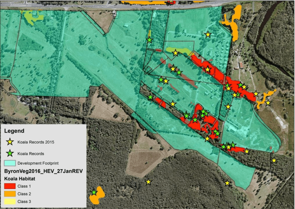 BSC identified Koala habitat and combined Koala records at West Byron, overlaid with the development footprint. Two hectares of core Koala habitat is proposed for clearing and the remaining habitat fragmented and surrounded by development. Note that while there is a strong correspondence between Koala records and mapped Class 1 and 2 habitat, Koalas were also frequently found to be using trees outside mapped habitat.
Buffers
The requirements of the draft Byron Coast Comprehensive Koala Plan of Management Plan and DCP for the implementation of 50m buffers to mitigate impacts on core Koala habitat have been completely ignored.
Koala Feed Trees
It is clear that the proposed planting of Swamp Mahogany as the compensation for the clearing of core Koala habitat and individual feed trees will not provide equivalent resources as those lost for many decades, with many trees unlikely to ultimately provide suitable browse. There is a need to identify the locations and sizes of all potential feed trees proposed for removal in order to fully assess the impacts of the proposed developments. It is apparent that for decades to come that the objective of DCP E8.10.5.1 Biodiversity and Vegetation Management to “Improve koala ecological values on the site” and the objective of SEPP 44 to “provide habitat for koalas to ensure a permanent free-living population over their present range and reverse the current trend of koala population decline” will not be met under these tree removal proposals.
Roads
A variety of standard mitigation measures of unknown veracity are proposed for internal roads. As well as signs limiting speeds it is considered that speed humps that limit speeds to below 20km per hour are required where roads are adjacent to or cross environmental zones.
The proposed Koala underpass under Ewingsdale Road near Sunrise Boulevard is strongly supported.
Dogs
The Local Landholder’s proposal to fence off Koala habitat so as to allow dogs in developed areas conflicts with Villaworld’s proposal to abide by the DCP and prohibit dogs, particularly on the interface between both developments. It should be unacceptable for such a significant proposal as dog/koala proof fencing to be put forward in contravention of the DCP without identifying its proposed location so its impacts can be assessed and considered. There are all sorts of problems associated with the erection of such fencing in an urban area, particularly with four road and one bicycle crossings. It is assumed that it is likely that if this is approved that it will involve fencing Koalas out of some environmental zones. It is evident that even if all the habitat remains available that access will be significantly reduced by the fencing excluding access from most directions. This will further limit the effective availability of habitat on the site.
Environment Protection and Biodiversity Conservation Act Referral
It is assessed that the development proposals meet the ‘EPBC Act Referral Guidelines for the vulnerable koala (combined populations of Queensland, New South Wales and the Australian Capital Territory)’ and should be referred to the Federal Environment Minister for consideration under the EPBC Act.
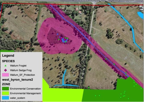
Wallum Sedge Frog
There are two local populations of the nationally vulnerable Wallum Sedge Frog (Olongburra Frog) on West Byron, a western population in a 0.65ha wetland that is known to have been present for the past 8 years and an eastern population known from one individual found in 2010 that has not been resurveyed to assess its status. Wallum Sedge Frogs have strict habitat requirements for highly acidic, shallow, ephemeral waterbodies and are thus highly vulnerable to changes in water quality and flows from urban development upstream.
The “National recovery plan for the wallum sedgefrog and other wallum-dependent frog species” identifies a variety of key threatening processes and mitigation actions that are applicable to the proposals. It is reprehensible that the undertaking given for the rezoning process was to protect both populations, though this commitment is not now being honoured.
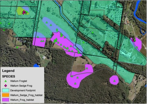
Frog locations and frog habitat (as identified by AWC 2011), overlaid with the development footprint. Note that the western population of Wallum Sedge Frog is proposed to be eliminated and the eastern population has little prospects of survival.
Eastern Population
Aside from the 2010 record there is no evidence that anybody has bothered to assess the current status and extent of the Eastern population. Further work is required to assess the status of this population and the habitat utilised, which should have been undertaken for the DA.
No assessment has been made of the likely affects of runoff and stormwater from the extensive development in the catchment on the water quality (notably pH and turbidity) and flow parameters (water depth and permanence) necessary for Wallum Sedge Frogs, particularly with the concentration of stormwater from a large urban area being directed into this stream. There can be no doubt that these will be significantly altered, likely causing the elimination of this population. Similarly no buffer to the location where the frog was recorded is proposed, with fill, swales and drains immediately adjacent to the only known record (intruding into the Ezone). The requirements of the DCP and Recovery Plan have not been complied with.
For the eastern population there has been no test for determining whether the proposed development is likely to significantly affect the Wallum Sedge Frog and its habitat in accordance with section 7.3 of the Biodiversity Conservation Act 2016.
There can be no doubt that the works comprise the Key Threatening Processes of ‘Alteration to the natural flow regimes of rivers and streams and their floodplains and wetlands’ and ‘Clearing of Native Vegetation’ and because of increased runoff are likely to exasperate ‘Predation by Gambusia holbrooki’ (Mosquito Fish). In compliance with the Biodiversity Conservation Act 2016A a Species Impact Statement or a Biodiversity Development Assessment Report needs to be prepared.
Western Population
The western population of the Wallum Sedge Frog occupies a 0.65ha wetland identified as an Endangered Ecological Community positioned on the principal dispersal corridor from the wetlands near the STP to the north and the Cumbebin Wetlands to the south. It is a significant population. To be compliant with the “National recovery plan for the wallum sedgefrog and other wallum-dependent frog species” a 50m buffer should be placed around the wetland and a 20m buffer around the drainage line forming the corridor through West Byron. A frog underpass of Ewingsdale Road needs to be provided as part of the intersection upgrade.
Contrary to undertakings given for the rezoning the intention is to place 3m of fill, houses and roads over this wetland and totally eliminate the wetland and a local population of the Wallum Sedge Frog. Villaworld are proposing using Biobanking to offset the loss of this population. While denied by the developer there can be no doubt that this will have a significant impact and that in compliance with the Biodiversity Conservation Act 2016A a Species Impact Statement or a Biodiversity Development Assessment Report needs to be prepared.
Proposed protection for the Wallum Sedge Frog, providing 50m buffer around its habitat and 20m buffer to drainage line linking it to wetlands to the south east, with linkage through to Ewingsdale Road. It is considered that an underpass under the road needs to be provided and linkages provided along drains to wetlands to the north west.
Mitigation
The proposal to construct artificial wetlands as a mitigation action is an untested experiment that cannot be guaranteed to be successful for the Wallum Sedge Frog, and therefore cannot be relied upon for mitigation. Even if it was successful the elimination of the dispersal link through to other populations will stop the ability for recolonisation and genetic exchange to maintain the genetic fitness of the West Byron populations, and thus their long-term viability.
The proponent is intending to eliminate an important breeding population of the Wallum Sedge Frog within what appears to be an important habitat linkage between populations to the south and north. The Commonwealth’s Draft referral guidelines for the vulnerable wallum sedge frog, Litoria olongburensis (2011) make it abundantly clear that this development should be referred to the Federal Minister in accordance with the EPBC Act.
