
Download the submission prepared by BEACON’s Dailan Pugh
if you need ideas for your own.
Byron Shire Council will not be deciding the Development Application for the first subdivision of the West Byron site. All developments over $20 million are decided by the Joint Regional Planning Panel.
About the JRPP: The JRPP is a state government entity and their approval rate for developments that have come before them is almost 100% We have to make a strong representation if we want them to consider the community and the environment in their decision making.
The developers, Villa World, have put in a Development Application to Council for Stage 1 of a suburban subdivision (to be called ‘Harvest Estate’). Council will collect the submissions from the public exhibition of the development application. Council also makes its own submission to the JRPP.
Where to send it: submissions@byron.nsw.gov.au
Also send to the following:
Anthony Roberts, Minister for Planning
office@roberts.minister.nsw.gov.au
Ben Franklin MLC Parliamentary Secretary for Northern NSW ben.franklin@parliament.nsw.gov.au
Tamara Smith MLA, Greens Member for Ballina ballina@parliament.nsw.gov.au
Justine Elliot MP, Federal Member for Richmond Justine.Elliot.MP@aph.gov.au
Walt Secord MLC Shadow Min. for the North Coast walt.secord@parliament.nsw.gov.au
Dawn Walker, Greens MLC, dawn.walker@parliament.nsw.gov.au
Gabrielle Upton MP, Minister for the Environment vaucluse@parliament.nsw.gov.au
Below are some ideas for your submission. Please note this is BY NO MEANS EXHAUSTIVE.
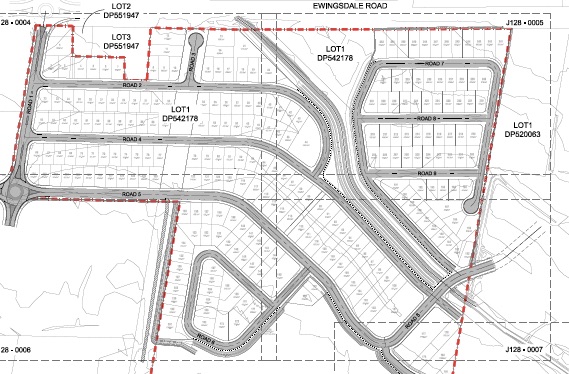
This is only the beginning of the 1000+ lots we are likely to see on the whole of West Byron. The reasons this DA should be rejected are many.
Because the site is made up of VillaWorld’s subdivision proposal as well as that of the other landowners, there are aspects of the site that cannot be dealt with in isolation. These include impacts on traffic, drainage, koalas and wetlands.
- Insufficient information
The application contains detailed information regarding the Stage 1 component of the application, but no information is provided to enable a proper assessment of the Concept Plan for the whole of the development.
- TRAFFIC
The traffic impacts of the development are hugely underestimated in the DA.
The traffic study undertaken by the proponents is limited to only the western part of West Byron and the partial impacts on one of the two roundabouts. Previous studies have identified the existing chronic traffic problems with the main entry into town, and predicted rapidly deteriorating conditions as traffic volumes increase. Increasing congestion has exceeded predictions and estimates need revision.
There has been no study that has considered the full development. It is clear that there has been no traffic study that adequately, fully or accurately identifies the likely consequences that either the full or partial development of West Byron will have on “the safety, efficiency and ongoing operation” of Ewingsdale Road, Shirley Street or the town centre and roundabouts. A traffic study needs to be prepared that identifies measures, including appropriate staging of the whole development, that ensures Ewingsdale Road “will not be adversely affected by the development”.
- DRAINAGE, WATER AND FILL
The site is a drained wetland that is flood affected. It is directly adjacent to the Belingil Creek and close to the estuary. Placing hard surfaces on it such as roads and slabs will decrease the capacity of the land to absorb water which has to find a way to drain, eventually, into the Belongil. Added to this is the massive amount of fill that will exacerbate run off. Our wetlands are precious and must be protected.
Uncontrolled stormwater can degrade land and downstream environments through erosion, sedimentation, the altering of nutrient levels, increasing levels of pollution, the spread of weeds, and exacerbated flooding. The design of stormwater measures must be part of an overall stormwater management plan based on an assessment of potential impact on adjoining land. This must be done before any work is considered on the site.
The developers have been directed to no dig below the water table – this would activate the acid sulfate soils – so they have to fill the site to enable earthworks to take place. In some areas they are proposing to fill as much as 3 metres to meet the allowed developable level.
This amount of fill is of serious concern because the impacts that raising the level of one area will have on drainage to adjacent areas is likely to be significant. Without a whole of site plan for fill and drainage, the impacts of so large a fill amount are unknown.
The engineering report indicates that a total of 168,800m3 of fill material will need to be imported to the site for the Stage 1 development (no indication is given for total fill amount for overall Concept Plan). This will mean thousands of truck movements on Ewingsdale Road. The DA claims the fill will be sourced from local quarries but does not say if the amount required is available locally.
The quality of the fill is of particular concern as the potential of it to go into the Belongil – particularly at the building phase – is a genuine concern. This is a site that drains to Belongil Creek and Estuary which is a Special Purpose Zone of the Cape Byron Marine Park and an important fish breeding and bird roosting are that cannot be allowed to be contaminated.
The DA also says 12,800 m3 of the fill will be found on site which means that some areas will be excavated up to 2m. This is very concerning in a known acid sulfate hot spot.
The other serious consideration is the impact that piling large amount of fill will have on neighbouring properties and the increased amount of water flowing into the Belongil.
4. Biodiversity
Koalas
The Byron Coast Koala Habitat Study maps this locality as an area of significant activity. The site is a known area of koala connectivity to the koala population to the north and the linkages between the two population areas are essential for their breeding and continuing population. The VillaWorld DA suggests that a Koala Plan of Management is not required. The West Byron DCP E8.10.5.1 requires the preparation of a Koala Plan of Management (KPoM). A Koala Plan of Management for the whole site must be prepared
The fragile nature of Byron’s Coastal Koala population must not be further threatened by this kind of intensive development. Four hectares of native trees are to be removed.
Frogs
Wallum frog habitat is to be removed with a bio-banking agreement suggested as an appropriate offset mechanism.* The Wallum Frogs should be protected and their habitat restored or enhanced under the National Recovery Plan for the Wallum Sedge Frog and other Wallum dependent frog species. We do not support removal of a threatened species.
5. Appearance and Character
The West Byron DCP asserts that the development would be “a vibrant mixed use village centre to provide a community meeting place and to provide retail and commercial opportunities.”
This development is far from that aspiration – the housing arrangements are very conventional yet different from the existing Byron Shire suburbs. This development has nearly all 450 sqm lots; more dense than most of Byron. The village components appear to be within Stage 2 and no detail is provided.
There are 5 lots that are medium density (in a low density zone). They are proposed to be three storey and 13.4 metres high. The height limit in the Byron LEP is 9m.
There is no innovation or point of difference about this subdivision evident in the DA. The block size being so small, the visual impact will be a sea of roofs. The amount of green space among the houses is minimal. It is clearly laid out for maximum density on the site.
Although the proponents claimed the development would be designed to encourage bicycle use, there are no bike paths (except for a tiny part around the community use area), presumably to increase block yields. The internal roads are marked at 50 km/h and there are no shared use 10 km/h zones.
- From the Office of Environment and Heritage website:
BioBanking is a market-based scheme that provides a streamlined biodiversity assessment process for development, a rigorous and credible offsetting scheme as well as an opportunity for rural landowners to generate income by managing land for conservation. BioBanking enables ‘biodiversity credits’ to be generated by landowners and developers who commit to enhance and protect biodiversity values on their land through a biobanking agreement. These credits can then be sold, generating funds for the management of the site. Credits can be used to counterbalance (or offset) the impacts on biodiversity values that are likely to occur as a result of development.
